Ramani Tandale: Work In Progress
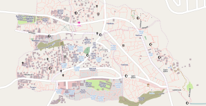
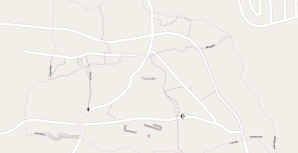
Posted: August 22nd, 2011 | Author: mark | Filed under: tandale, Tanzania | 2 Comments »Two weeks or so ago IÂ posted about the impending Map Tandale project. In it I spoke about the broad aims of the project and the methodology. It was accompanied by an almost blank slate; the map below. This is compared with the map above taken on the 19th of August 2011.
Quite a lot of progress here! One thing that should be considered is the schedule upto this point. We held the community forum on Tuesday 9th of August. Wednesday was about the community and students working together and getting familiarity with the GPS;mapping with your feet. Thursday and Friday downloading GPS tracks and editing with JOSM was covered. Because of enthusiastic community members and students we ran an additional session on Saturday, attended by a few, to further explore the editing process.
This meant on Monday we could really get started with mapping with everyone at the same skill level, and we did. I now think we’ve got around 90-95% of the major tracks done, the rest of the tracks should be finished on Monday/Tuesday. POIs like water tanks and toilets are in, again we have some areas that need to be mapped and these will be picked up by Tuesday.
Because of us nearing completion we’ve entered phase two of the project; using the map we’ve created to tell stories and highlight issues. To do this we’re usingUshahidi, categorising reports and issues along Water, Health,  Education, Accessibility and Security. These themes were identified, not through previous experience, but from community members themselves.
In the community forum they provided areas where they believe improvement is needed. With us delivering on a system that monitors what they want monitoring we hope to give the community ownership of the project. Once the taxonomy exists within Ushahidi we requested that the community enter some of the issues that they face along the identified themes. After familiarity with the system was gained they then went out into their sub-wards, their communities, and gathered stories and issues that were happening then. The website for the Ushahidi instance is http://tandale.ramanitanzania.org/ushahidi/, please do have a look at it, though you will probably have to translate the reports!
One point of note is the name of the project; also chosen by the community. Ramani is Swahili for map. Ramani Tanzania, Map Tanzania. I believe that the community really feel part of something and are anxious to contribute further.
Understandably this is only the first step, realistically we are barely two weeks into the project, however it is shaping up well. In the coming weeks we will focus on using the map to tell the stories and issues in Tandale and looking how the project can become sustainable with a tangible benefit.
So far the tangible benefits encompasses the urban planning students who have gained surveying knowledge and the community members who have improved their own skills with technology, however we want the project to succeed and be a continuing success. To do this involvement needs to occur between Community Based Organisations, Non-Governmental Organisations, Charities and the City Council. We have already engaged these actors on varying levels but will ramp up interaction in the coming weeks.
As a parting note I would like to personally thank Lucy Fondo and Hassan Abdalla from Map Kibera. They engaged the community members and students with equal aplomb and along with Simon Kokoyo, from Map Mathare, smoothed the implementation of the project removing obstacles like language, making it child’s play.
Written and submitted in the Tandale Ward Office, Dar Es Salaam, Tanzania (-6.797164,39.242736)


[…] can edit OSM quickly and to great effect. The ‘ramaniTanzania’ project recently mapped Tandale. Here’s what OSM had […]
Great example of community mapping – we need to do the same for Arusha!